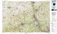
1986 Map of East Liverpool
USGS Topo · Published 1989About this map
The Ohio River carves a dominant path through this tri-state industrial and rural landscape, serving as a historic conduit for the settlements of East Liverpool and Wellsville. In the mid-1980s, the region's complex geography is defined by the confluence of the Beaver River and the Ohio, where towns like Monaca and Rochester anchor the riverfront. The map illustrates a dense network of transit and industry, including the Conrail lines and the heavy-duty Turnpike corridor crossing the northern reaches near Salem and Columbiana.
Find a feature on this map
82 named features on this map. Tap any name to fly to it.
Don’t see what you’re looking for? This feature index may not catch every label — zoom into the map to look around manually.
Map Details
Editions of this 1986 East Liverpool Map
2 editions found
Other maps of this area

1901 · Cadiz
USGS Topo · 1:62,500

1901 · Beaver
USGS Topo · 1:62,500

1902 · New Castle
USGS Topo · 1:62,500

1902 · Scio
USGS Topo · 1:62,500

1903 · Cadiz
USGS Topo · 1:62,500

1904 · Newcastle
USGS Topo · 1:62,500

1904 · Wellsville
USGS Topo · 1:62,500

1904 · Steubenville
USGS Topo · 1:62,500

1904 · Mc Keesport
USGS Topo · 1:62,500

1904 · Beaver
USGS Topo · 1:62,500