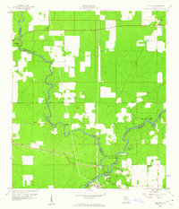
1959 Map of Ellaville
USGS Topo · Published 1960About this map
The confluence of the Withlacoochee River and the Suwannee River serves as the geographic heart of this North Florida landscape, where the borders of Madison, Hamilton, and Suwannee counties meet. In the late 1950s, the small settlement of Ellaville remained a focal point of local activity, situated near the Seaboard Air Line tracks and the Suwannee River State Park. The map documents a community deeply rooted in its environment, with several distinct water sources like Suwanacoochee Spr, Adams Spring, and Morgans Spring dotting the terrain.
Find a feature on this map
26 named features on this map. Tap any name to fly to it.
Don’t see what you’re looking for? This feature index may not catch every label — zoom into the map to look around manually.
Map Details
Editions of this 1959 Ellaville Map
5 editions found
Other maps of this area

1954 · Valdosta
USGS Topo · 1:250,000

1956 · Jennings
USGS Topo · 1:24,000

1956 · Octahatchee
USGS Topo · 1:24,000

1958 · Valdosta
USGS Topo · 1:250,000

1958 · Fort Union
USGS Topo · 1:24,000

1958 · Madison SE
USGS Topo · 1:24,000

1958 · Lee
USGS Topo · 1:24,000

1959 · Valdosta
USGS Topo · 1:250,000

1959 · Ellaville
USGS Topo · 1:24,000

1959 · Live Oak West
USGS Topo · 1:24,000