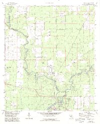
1959 Map of Ellaville
USGS Topo · Published 1993About this map
The confluence of the Withlacoochee River and the Suwannee River anchors this 1959 survey of the Florida borderlands, where Madison and Hamilton counties meet. The landscape is defined by the hydrologic complexity of the region, featuring numerous groundwater outlets such as Morgans Spring, Adams Spring, and Suwanacoochee Spring. This area is preserved in part by the Suwannee River State Park, which protects both the natural riverbanks and sites of deep local significance. Near the southern river junction, the settlement of Ellaville is visible alongside the historic Drew Mansion. Local heritage is further evidenced by a network of country churches and burial grounds, including St Pauls Ch, Corinth Ch, and the Old Columbus Cem, providing essential landmarks for genealogists and researchers tracking early families in this rural riverine corridor.
Find a feature on this map
28 named features on this map. Tap any name to fly to it.
Don’t see what you’re looking for? This feature index may not catch every label — zoom into the map to look around manually.
Map Details
Editions of this 1959 Ellaville Map
5 editions found
Other maps of this area

1954 · Valdosta
USGS Topo · 1:250,000

1956 · Jennings
USGS Topo · 1:24,000

1956 · Octahatchee
USGS Topo · 1:24,000

1958 · Valdosta
USGS Topo · 1:250,000

1958 · Fort Union
USGS Topo · 1:24,000

1958 · Madison SE
USGS Topo · 1:24,000

1958 · Lee
USGS Topo · 1:24,000

1959 · Valdosta
USGS Topo · 1:250,000

1959 · Ellaville
USGS Topo · 1:24,000

1959 · Live Oak West
USGS Topo · 1:24,000