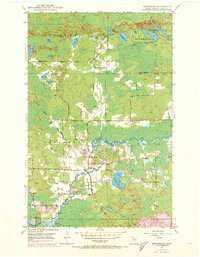
1949 Map of Embarrass
USGS Topo · Published 1973About this map
Embarrass serves as the focal point of this northern Minnesota survey, situated along the winding course of the Embarrass River. The landscape is a complex network of glacial lakes and wetlands, including Heikkilla Lake, Moose Lake, and Little Birch Lake, much of which falls within the Minnesota State Forest. Local history is anchored by School No 70 and the settlement pattern follows the Duluth Missabe and Iron Range railroad line. Industrial activity is visible at the southern edge, where a large Tailings Pond indicates the region's mining heritage near Mesaba. The map also captures several smaller water bodies with local identifiers like Lempia Lakes and Fishing Lakes, alongside tributary systems such as Bear Creek and Camp Eight Creek.
Find a feature on this map
28 named features on this map. Tap any name to fly to it.
Don’t see what you’re looking for? This feature index may not catch every label — zoom into the map to look around manually.
Map Details
Editions of this 1949 Embarrass Map
4 editions found
Other maps of this area

1949 · Aurora
USGS Topo · 1:24,000

1949 · Isaac Lake
USGS Topo · 1:24,000

1949 · Allen
USGS Topo · 1:24,000

1949 · Embarrass
USGS Topo · 1:24,000

1950 · Isaac Lake
USGS Topo · 1:24,000

1950 · Embarrass
USGS Topo · 1:24,000

1950 · Allen
USGS Topo · 1:24,000

1950 · Aurora
USGS Topo · 1:24,000

1950 · Biwabik
USGS Topo · 1:24,000

1950 · Biwabik NE
USGS Topo · 1:24,000