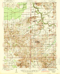
1944 Map of Enfield
USGS Topo · Published 1944About this map
Enfield and Mill Shoals serve as the primary hubs in this mid-century look at the border between Hamilton and White Counties. The landscape is defined by the winding course of Skillet Fork and a dense network of steam-era rail lines, including the Baltimore and Ohio, Louisville and Nashville, and Southern railroads. The map reveals an agrarian society organized around dozens of small neighborhood institutions, such as Doeskin Sch, Bunker Hill Sch, and Hickory Valley Sch.
Find a feature on this map
82 named features on this map. Tap any name to fly to it.
Don’t see what you’re looking for? This feature index may not catch every label — zoom into the map to look around manually.
Map Details
Editions of this 1944 Enfield Map
2 editions found

Other maps of this area

1905 · Eldorado
USGS Topo · 1:62,500

1905 · New Haven
USGS Topo · 1:62,500

1906 · New Haven
USGS Topo · 1:62,500

1906 · Eldorado
USGS Topo · 1:62,500

1908 · Galatia
USGS Topo · 1:62,500

1938 · Galatia
USGS Topo · 1:62,500

1940 · Carmi
USGS Topo · 1:62,500

1941 · Enfield
USGS Topo · 1:62,500

1942 · McLeansboro
USGS Topo · 1:62,500

1943 · Carmi
USGS Topo · 1:62,500