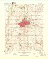
1955 Map of Enid
USGS Topo · Published 1974About this map
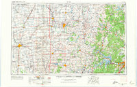
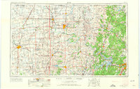
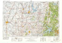
The Osage Indian Reservation dominates the eastern half of this landscape, characterized by the winding path of the Arkansas River and several massive water projects. By the mid-1960s, the emergence of the Kaw Reservoir, Hulah Reservoir, and Keystone Lake significantly altered the regional hydrology, drowning former floodplains to manage the flow of the Caney River and Verdigris River. This era of civil engineering is contrasted by the established agricultural and industrial infrastructure of the west, where the Atchison Topeka and Santa Fe and other major rail lines connect towns like Blackwell, Tonkawa, and Newkirk. Notable specialized institutions appear on the border, such as the Chilocco Indian Agricultural School. The regional economy is further evidenced by a network of oil wells, tanks, and the Naval Reserve Oil Field, illustrating the critical role of energy production alongside the military presence at Vance AFB.
Find a feature on this map
172 named features on this map. Tap any name to fly to it.
Don’t see what you’re looking for? This feature index may not catch every label — zoom into the map to look around manually.
Map Details
Editions of this 1955 Enid Map
4 editions found

Historical Maps of Tulsa Through Time
4 maps found