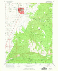
1966 Map of Ephraim
USGS Topo · Published 1969About this map
Snow College and its Field Station anchor the academic and civic life of Ephraim during the mid-1960s, while the Denver and Rio Grande Western railroad tracks cut a diagonal path across the agricultural Sanpete Valley. To the west, the landscape is defined by extensive irrigation networks including the Larsen Ditch and numerous flowing wells, essential for the valley's farms. To the east, the terrain rises sharply into the Manti-La Sal National Forest, where steep canyons like Ephraim Canyon and New Canyon dominate. The map documents a period of local utility and leisure, from the Manti-Ephraim Airport and the Drive-in Theatre on the town's edge to the Manti Community Campground and Yearns Reservoir high in the mountains. Traces of early industrial activity are visible at the Quarry and various Gravel Pits scattered near the foothills.
Find a feature on this map
62 named features on this map. Tap any name to fly to it.
Don’t see what you’re looking for? This feature index may not catch every label — zoom into the map to look around manually.
Map Details
Editions of this 1966 Ephraim Map
2 editions found
Other maps of this area

1885 · Manti
USGS Topo · 1:250,000

1895 · Manti
USGS Topo · 1:250,000

1922 · Wasatch
USGS Topo · 1:31,680

1956 · Price
USGS Topo · 1:250,000

1960 · Price
USGS Topo · 1:250,000

1962 · Price
USGS Topo · 1:250,000

1965 · Manti
USGS Topo · 1:24,000

1965 · Wales
USGS Topo · 1:24,000

1965 · Black Mountain
USGS Topo · 1:24,000
1966 · Ferron Reservoir
USGS Topo · 1:24,000