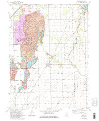
1973 Map of Essex
USGS Topo · Published 1981About this map
Reed Mines dominate the northwestern landscape of this Illinois quadrangle, showing the extensive earth-moving and water-filled pits of the local coal industry. This industrial footprint is bordered by the Gulf Mobile and Ohio and Norfolk and Western railroads, which helped facilitate the region's transport network. The village of Essex serves as a central hub, while smaller clusters like Godley, Torino, and Clarke City highlight the scattered settlement patterns typical of this mining and agricultural district.
Find a feature on this map
27 named features on this map. Tap any name to fly to it.
Don’t see what you’re looking for? This feature index may not catch every label — zoom into the map to look around manually.
Map Details
Editions of this 1973 Essex Map
3 editions found
Other maps of this area

1892 · Morris
USGS Topo · 1:62,500

1892 · Wilmington
USGS Topo · 1:62,500

1918 · Wilmington
USGS Topo · 1:62,500

1918 · Morris
USGS Topo · 1:62,500

1923 · Herscher
USGS Topo · 1:62,500

1925 · Herscher
USGS Topo · 1:62,500

1948 · Dwight
USGS Topo · 1:62,500

1950 · Dwight
USGS Topo · 1:62,500

1953 · Coal City
USGS Topo · 1:24,000

1953 · Symerton
USGS Topo · 1:24,000