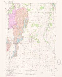
1973 Map of Essex
USGS Topo · Published 1981About this map
The Kankakee River winds through the northeastern corner of this Kankakee County landscape, providing a sharp contrast to the industrial and agricultural patterns that dominate the rest of the quadrangle. The village of Essex serves as a central hub, surrounded by smaller settlements like Godley, Torino, and the site of Clarke City. A significant portion of the western terrain is defined by large-scale earthworks and water features, likely associated with the region's strip-mining history, which has reshaped the natural drainage of Granary Creek.
Find a feature on this map
31 named features on this map. Tap any name to fly to it.
Don’t see what you’re looking for? This feature index may not catch every label — zoom into the map to look around manually.
Map Details
Editions of this 1973 Essex Map
3 editions found
Other maps of this area

1892 · Morris
USGS Topo · 1:62,500

1892 · Wilmington
USGS Topo · 1:62,500

1918 · Wilmington
USGS Topo · 1:62,500

1918 · Morris
USGS Topo · 1:62,500

1923 · Herscher
USGS Topo · 1:62,500

1925 · Herscher
USGS Topo · 1:62,500

1948 · Dwight
USGS Topo · 1:62,500

1950 · Dwight
USGS Topo · 1:62,500

1953 · Coal City
USGS Topo · 1:24,000

1953 · Symerton
USGS Topo · 1:24,000