
Loading...
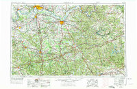
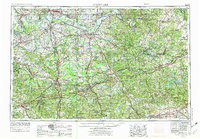
Loading map...1957 Map of Evansville
USGS Topo · Published 1969About this map
The Ohio River forms the central spine of this landscape, carving a meandering border between Indiana and Kentucky during a period of significant regional growth. Major river ports like Evansville, Owensboro, and Henderson serve as industrial and transit hubs, connected by a dense network of iron and asphalt. The rail-to-road transition is evident as the Illinois Central RR and Louisville and Nashville RR operate alongside newly established routes like the Pennyrile Parkway.
Find a feature on this map
67 named features on this map. Tap any name to fly to it.
Don’t see what you’re looking for? This feature index may not catch every label — zoom into the map to look around manually.
Map Details
Date Portrayed1957
Date Published1969
PublisherU.S. Geological Survey
Map TypeTopographic
Scale1:250,000
Physical Dimensions32.1 x 22.1 inches
Editions of this 1957 Evansville Map
3 editions found
Historical Maps of Evansville Through Time
6 maps found


Featured Locations
Source Details
SourceU.S. Geological Survey
CopyrightPublic Domain