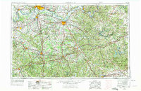
1957 Map of Evansville
USGS Topo · Published 1975About this map
The Ohio River and its massive tributaries define this mid-1970s landscape, which spans the border of Indiana and Kentucky. Regional centers like Evansville, Owensboro, and Bowling Green appear as established hubs connected by a dense lattice of federal highways and major railroads, including the Illinois Central Gulf RR and Louisville & Nashville RR. The industrial character of the Western Kentucky Coal Field is evident near Central City and Madisonville where extensive Strip Mine operations are recorded.
Find a feature on this map
108 named features on this map. Tap any name to fly to it.
Don’t see what you’re looking for? This feature index may not catch every label — zoom into the map to look around manually.
Map Details
Editions of this 1957 Evansville Map
3 editions found

Other maps of this area

1900 · St Meinrad
USGS Topo · 1:62,500

1900 · De Gonia Springs
USGS Topo · 1:62,500

1901 · Owensboro
USGS Topo · 1:62,500

1901 · Haubstadt
USGS Topo · 1:62,500

1902 · Ditney
USGS Topo · 1:125,000

1902 · Degonia Springs
USGS Topo · 1:62,500

1902 · Boonville
USGS Topo · 1:62,500

1903 · St. Meinrad
USGS Topo · 1:62,500

1903 · Haubstadt
USGS Topo · 1:62,500

1903 · New Harmony
USGS Topo · 1:62,500