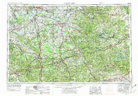
1957 Map of Evansville
USGS Topo · Published 1975About this map
The Ohio River carves a winding path across this mid-century landscape, serving as the primary geographic artery for river towns like Evansville, Owensboro, and Henderson. This 1957 compilation, revised in the 1970s, illustrates the complex intersection of industry and nature in the Illinois Basin. Expansive Strip Mines are concentrated around Central City and Madisonville, while the eastern reaches are defined by the unique karst topography of Mammoth Cave National Park and the rugged terrain known as The Knobs.
Find a feature on this map
93 named features on this map. Tap any name to fly to it.
Don’t see what you’re looking for? This feature index may not catch every label — zoom into the map to look around manually.
Map Details
Editions of this 1957 Evansville Map
3 editions found

Other maps of this area

1900 · St Meinrad
USGS Topo · 1:62,500

1900 · De Gonia Springs
USGS Topo · 1:62,500

1901 · Owensboro
USGS Topo · 1:62,500

1901 · Haubstadt
USGS Topo · 1:62,500

1902 · Ditney
USGS Topo · 1:125,000

1902 · Degonia Springs
USGS Topo · 1:62,500

1902 · Boonville
USGS Topo · 1:62,500

1903 · St. Meinrad
USGS Topo · 1:62,500

1903 · Haubstadt
USGS Topo · 1:62,500

1903 · New Harmony
USGS Topo · 1:62,500