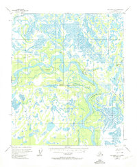
1950 Map of Fairbanks D-5
USGS Topo · Published 1974About this map
The Tanana River meanders through this interior Alaska landscape, defining a complex network of waterways and wetlands. The settlement of Old Minto is situated along the riverbank, accompanied by a nearby Landing Strip that highlights the region's reliance on bush aviation. This 1950s-era topography reveals a transition in transportation, where a traditional Sled Road parallels the water, cutting through the marshes and muskeg toward the north.
Find a feature on this map
18 named features on this map. Tap any name to fly to it.
Don’t see what you’re looking for? This feature index may not catch every label — zoom into the map to look around manually.
Map Details
Editions of this 1950 Fairbanks D-5 Map
3 editions found
Other maps of this area

1945 · Livengood
USGS Topo · 1:250,000

1949 · Fairbanks D-4
USGS Topo · 1:63,360

1950 · Fairbanks
USGS Topo · 1:250,000

1950 · Fairbanks C-5
USGS Topo · 1:63,360

1950 · Fairbanks C-4
USGS Topo · 1:63,360

1950 · Fairbanks D-5
USGS Topo · 1:63,360

1951 · Fairbanks
USGS Topo · 1:250,000

1951 · Livengood
USGS Topo · 1:250,000

1951 · Livengood A-5
USGS Topo · 1:63,360

1951 · Livengood A-4
USGS Topo · 1:63,360