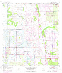
1953 Map of Fellsmere 4 NE
USGS Topo · Published 1977About this map
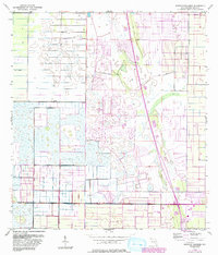
Vero Lake Estates marks a developing residential pattern in Indian River County as documented in this mid-century survey. The landscape is heavily defined by extensive water management infrastructure, where a network of Levee systems and Spoil Banks crisscross the terrain. These man-made features indicate a significant transformation of the natural drainage patterns, likely to facilitate both agricultural expansion and new subdivisions. The map reflects a period of transition, showing the early layout of residential streets in the north and a localized Trailer Park to the south, set against a backdrop of complex canal and levee engineering that made this coastal Florida environment habitable for growing communities.
Find a feature on this map
7 named features on this map. Tap any name to fly to it.
Don’t see what you’re looking for? This feature index may not catch every label — zoom into the map to look around manually.
Map Details
Editions of this 1953 Fellsmere 4 NE Map
5 editions found
Other maps of this area

1949 · Fellsmere
USGS Topo · 1:24,000

1949 · Vero Beach
USGS Topo · 1:24,000

1949 · Sebastian
USGS Topo · 1:24,000

1949 · Oslo
USGS Topo · 1:24,000

1950 · Oslo
USGS Topo · 1:24,000

1950 · Vero Beach
USGS Topo · 1:24,000

1951 · Fellsmere
USGS Topo · 1:24,000

1951 · Sebastian
USGS Topo · 1:24,000

1953 · Fellsmere SW
USGS Topo · 1:24,000

1953 · Fellsmere 4 SE
USGS Topo · 1:24,000