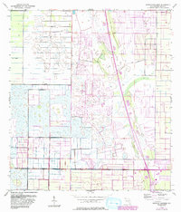
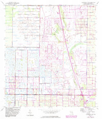
1953 Map of South of Fellsmere
USGS Topo · Published 1993About this map
The lowlands of Indian River County are defined by a complex engineering network of water management features, visible here in the mid-20th century. Numerous Levee structures and prominent Spoil Banks crisscross the terrain, reflecting the massive efforts to drain and reclaim this section of Florida's interior. In the northeastern corner, the residential footprint of Vero Lake Estates begins to emerge, contrasting with the largely rural and managed wetland character of the surrounding landscape.
Find a feature on this map
8 named features on this map. Tap any name to fly to it.
Don’t see what you’re looking for? This feature index may not catch every label — zoom into the map to look around manually.
Map Details
Editions of this 1953 South of Fellsmere Map
5 editions found
Other maps of this area

1949 · Fellsmere
USGS Topo · 1:24,000

1949 · Vero Beach
USGS Topo · 1:24,000

1949 · Sebastian
USGS Topo · 1:24,000

1949 · Oslo
USGS Topo · 1:24,000

1950 · Oslo
USGS Topo · 1:24,000

1950 · Vero Beach
USGS Topo · 1:24,000

1951 · Fellsmere
USGS Topo · 1:24,000

1951 · Sebastian
USGS Topo · 1:24,000

1953 · Fellsmere SW
USGS Topo · 1:24,000

1953 · Fellsmere 4 SE
USGS Topo · 1:24,000