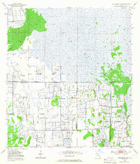
1953 Map of Fellsmere 4 SW
USGS Topo · Published 1967About this map
St Johns Marsh dominates the upper half of this 1950s survey, illustrating a Florida interior shaped by extensive water management and agricultural drainage efforts. The landscape is characterized by a dense grid of Levee and Spoil Bank systems that cut through the wetlands, particularly south of Sick Island and Gum Slough. These man-made features signal the early-to-mid-century transformation of the marshlands into productive territory, a process heavily reliant on the numerous instances of a Flowing Well scattered across the township lines. The survey also captures the precise convergence of three county lines, showing where the boundaries of Indian River, Okeechobee, and St. Lucie counties meet amidst the canal-divided terrain. This map serves as a detailed record of drainage engineering before modern environmental restoration efforts changed the region's hydraulic priorities.
Find a feature on this map
9 named features on this map. Tap any name to fly to it.
Don’t see what you’re looking for? This feature index may not catch every label — zoom into the map to look around manually.
Map Details
Editions of this 1953 Fellsmere 4 SW Map
4 editions found
Other maps of this area

1953 · Fort Drum
USGS Topo · 1:24,000

1953 · Fellsmere 4 SE
USGS Topo · 1:24,000

1953 · Fort Drum NE
USGS Topo · 1:24,000

1953 · Fellsmere 4 SW
USGS Topo · 1:24,000

1953 · Fellsmere 4 NW
USGS Topo · 1:24,000

1953 · Taylor Creek NE
USGS Topo · 1:24,000

1953 · Okeechobee 1 NE
USGS Topo · 1:24,000

1953 · Okeechobee 1 NW
USGS Topo · 1:24,000
1953 · Fellsmere 4 NE
USGS Topo · 1:24,000

1956 · Fort Pierce
USGS Topo · 1:250,000