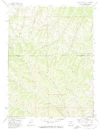
1971 Map of Figure Four Spring
USGS Topo · Published 1974About this map
Figure Four Spring sits within a complex network of drainage basins straddling the Rio Blanco Co and Garfield Co border. Surveyed in the early 1970s, the landscape is defined by its water sources and mining exploration, featuring numerous Prospect locations and Drill Holes scattered across the high terrain. The drainage patterns are highly localized, with distinct systems such as Black Sulphur Creek and Yankee Gulch in the north giving way to the branching headwaters of West Willow Creek and East Willow Creek to the south.
Find a feature on this map
23 named features on this map. Tap any name to fly to it.
Don’t see what you’re looking for? This feature index may not catch every label — zoom into the map to look around manually.
Map Details
Editions of this 1971 Figure Four Spring Map
2 editions found
Other maps of this area

1929 · Highmore
USGS Topo · 1:62,500

1952 · Yankee Gulch
USGS Topo · 1:24,000

1952 · Rock School
USGS Topo · 1:24,000

1956 · Grand Junction
USGS Topo · 1:250,000

1959 · Grand Junction
USGS Topo · 1:250,000

1960 · Grand Junction
USGS Topo · 1:250,000

1962 · Grand Junction
USGS Topo · 1:250,000

1964 · Grand Junction
USGS Topo · 1:250,000

1964 · Henderson Ridge
USGS Topo · 1:24,000

1964 · Black Cabin Gulch
USGS Topo · 1:24,000