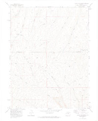
1971 Map of Figure Four Spring
USGS Topo · Published 1974About this map
Black Sulphur Creek and Yankee Gulch carve through this high-altitude landscape along the border of Rio Blanco and Garfield Counties. The 1970s terrain is characterized by a network of drainage systems, including West Fawn Creek and the curiously titled No Name Creek. Industrial activity is evident through numerous Prospect locations and Drill Holes, particularly near the Eureka site. The map documents a transition in land use, where rugged natural features like Red Point meet a sparse infrastructure of Jeep Trails and Pack Trails. Local hydrology is well-recorded, from the namesake Figure Four Spring to the clustered Springs feeding Mud Springs Creek, providing a detailed look at water sources essential for survey and resource extraction in this corner of Colorado.
Find a feature on this map
22 named features on this map. Tap any name to fly to it.
Don’t see what you’re looking for? This feature index may not catch every label — zoom into the map to look around manually.
Map Details
Editions of this 1971 Figure Four Spring Map
2 editions found
Other maps of this area

1929 · Highmore
USGS Topo · 1:62,500

1952 · Yankee Gulch
USGS Topo · 1:24,000

1952 · Rock School
USGS Topo · 1:24,000

1956 · Grand Junction
USGS Topo · 1:250,000

1959 · Grand Junction
USGS Topo · 1:250,000

1960 · Grand Junction
USGS Topo · 1:250,000

1962 · Grand Junction
USGS Topo · 1:250,000

1964 · Grand Junction
USGS Topo · 1:250,000

1964 · Henderson Ridge
USGS Topo · 1:24,000

1964 · Black Cabin Gulch
USGS Topo · 1:24,000