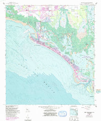
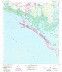
1958 Map of Fort Myers Beach
USGS Topo · Published 1991About this map
Estero Island serves as the focal point for this coastal survey, showcasing the mid-century development of Fort Myers Beach alongside its complex mangrove and bay ecosystems. The map documents a period of significant growth, with purple-tinted urban extensions spreading across San Carlos Island and the primary barrier island. These developments contrast with the preserved waters of the Estero Bay Aquatic Preserve, which protects a labyrinth of tidal features including Hell Peckney Bay and Julies Island. To the north, the landscape transitions from the Bunch Beach shoreline toward Truckland, while an old Railroad Grade hints at earlier transportation corridors. The bathymetric data reveals the shifting seafloor of the Gulf of Mexico and critical maritime passages such as Matanzas Pass and Big Carlos Pass that define the navigation of the Lee County coast.
Find a feature on this map
40 named features on this map. Tap any name to fly to it.
Don’t see what you’re looking for? This feature index may not catch every label — zoom into the map to look around manually.
Map Details
Editions of this 1958 Fort Myers Beach Map
5 editions found
Other maps of this area

1956 · West Palm Beach
USGS Topo · 1:250,000

1956 · Tampa
USGS Topo · 1:250,000

1956 · Charlotte Harbor
USGS Topo · 1:250,000

1957 · West Palm Beach
USGS Topo · 1:250,000

1958 · West Palm Beach
USGS Topo · 1:250,000

1958 · Bonita Springs
USGS Topo · 1:24,000

1958 · Estero
USGS Topo · 1:24,000

1958 · Fort Myers SW
USGS Topo · 1:24,000

1958 · Sanibel
USGS Topo · 1:24,000

1958 · Pine Island Center
USGS Topo · 1:24,000