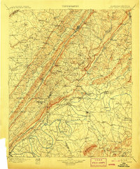
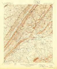
1900 Map of Fort Payne
USGS Topo · Published 1907About this map
Fort Payne sits at the heart of this Appalachian landscape, where the Alabama Great Southern R. R. follows the narrow valley between Sand Mountain and Lookout Mountain. The map reveals an intricate network of river-based commerce along the Coosa River, documented through numerous crossings such as Tripp Ferry, Wood Ferry, and Adams Ferry. These points of transit, alongside the Rome and Northern R. R., highlight the region's reliance on both rail and water for moving goods and people between Alabama and Georgia.
Find a feature on this map
179 named features on this map. Tap any name to fly to it.
Don’t see what you’re looking for? This feature index may not catch every label — zoom into the map to look around manually.
Map Details
Editions of this 1900 Fort Payne Map
6 editions found

Other maps of this area

1885 · Gadsden
USGS Topo · 1:125,000

1886 · Ringgold
USGS Topo · 1:125,000

1886 · Rome
USGS Topo · 1:125,000

1886 · Stevenson
USGS Topo · 1:125,000

1888 · Gadsden
USGS Topo · 1:125,000

1888 · Scottsboro
USGS Topo · 1:125,000

1889 · Tallapoosa
USGS Topo · 1:125,000

1889 · Springville
USGS Topo · 1:125,000

1892 · Ringgold
USGS Topo · 1:125,000

1892 · Springville
USGS Topo · 1:125,000