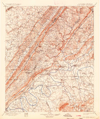
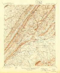
1900 Map of Fort Payne
USGS Topo · Published 1936About this map
Lookout Mountain and Sand Mountain dominate this landscape, their high ridges and deep gaps defining the settlement patterns of the late nineteenth century. In the valley between, Fort Payne serves as the primary hub along the Southern R. R., while the surrounding terrain is marked by dozens of narrow passages like Beeson Gap and Swindell Gap. The topography reveals a rugged economy of mountain-side milling and river-bottom transport, with Sauty Mills and Fisher Mill tapping highland water sources. The Coosa River and Chattooga River systems in the south are heavily threaded with ferries and fords, including Baskin Ferry and Mc Coy Ferry, providing essential connections before modern bridge infrastructure. From Manitou Cave near the city center to the remote heights of Mt. Brandon, this survey illustrates the intersection of Appalachian geology and frontier infrastructure at the turn of the century.
Find a feature on this map
173 named features on this map. Tap any name to fly to it.
Don’t see what you’re looking for? This feature index may not catch every label — zoom into the map to look around manually.
Map Details
Editions of this 1900 Fort Payne Map
6 editions found

Other maps of this area

1885 · Gadsden
USGS Topo · 1:125,000

1886 · Ringgold
USGS Topo · 1:125,000

1886 · Rome
USGS Topo · 1:125,000

1886 · Stevenson
USGS Topo · 1:125,000

1888 · Gadsden
USGS Topo · 1:125,000

1888 · Scottsboro
USGS Topo · 1:125,000

1889 · Tallapoosa
USGS Topo · 1:125,000

1889 · Springville
USGS Topo · 1:125,000

1892 · Ringgold
USGS Topo · 1:125,000

1892 · Springville
USGS Topo · 1:125,000