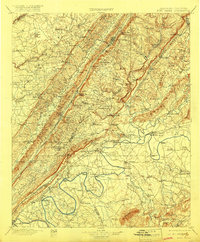
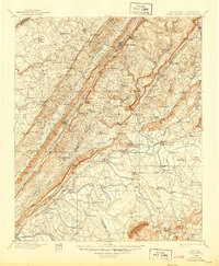
1900 Map of Fort Payne
USGS Topo · Published 1918About this map
Manitou Cave and the ridge-and-valley topography of northeastern Alabama define this late 19th-century survey. The landscape is marked by a transition from the elevated plateaus down to the Coosa River and the Chattanooga River, where a network of water-based transit supported local commerce. Numerous river crossings like Lawson Ford, Wood Ferry, and Baskin Ferry highlight how the population moved through the valley before modern bridges became common.
Find a feature on this map
218 named features on this map. Tap any name to fly to it.
Don’t see what you’re looking for? This feature index may not catch every label — zoom into the map to look around manually.
Map Details
Editions of this 1900 Fort Payne Map
6 editions found

Other maps of this area

1885 · Gadsden
USGS Topo · 1:125,000

1886 · Ringgold
USGS Topo · 1:125,000

1886 · Rome
USGS Topo · 1:125,000

1886 · Stevenson
USGS Topo · 1:125,000

1888 · Gadsden
USGS Topo · 1:125,000

1888 · Scottsboro
USGS Topo · 1:125,000

1889 · Tallapoosa
USGS Topo · 1:125,000

1889 · Springville
USGS Topo · 1:125,000

1892 · Ringgold
USGS Topo · 1:125,000

1892 · Springville
USGS Topo · 1:125,000