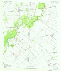
1952 Map of Francitas
USGS Topo · Published 1976About this map
East Carancahua Creek winds through the coastal plains of the Texas Gulf Coast, defining a landscape shaped by both natural drainage and industrial development. This mid-century survey illustrates the rural infrastructure of Jackson and Matagorda Counties, anchored by the settlement of Francitas and its adjacent Francitas Cem. The era's economic activity is prominently marked by Francitas Field, featuring a Gas Plant and several Evaporators, which underscore the region's reliance on petroleum and mineral extraction.
Find a feature on this map
16 named features on this map. Tap any name to fly to it.
Don’t see what you’re looking for? This feature index may not catch every label — zoom into the map to look around manually.
Map Details
Editions of this 1952 Francitas Map
2 editions found
Other maps of this area

1952 · Francitas NW
USGS Topo · 1:24,000

1952 · Palacios
USGS Topo · 1:24,000

1952 · Olivia
USGS Topo · 1:24,000

1952 · Turtle Bay
USGS Topo · 1:24,000

1952 · Francitas
USGS Topo · 1:24,000

1952 · Blessing
USGS Topo · 1:24,000

1952 · Francitas NE
USGS Topo · 1:24,000

1952 · Midfield
USGS Topo · 1:24,000

1952 · La Ward
USGS Topo · 1:24,000

1953 · Beeville
USGS Topo · 1:250,000