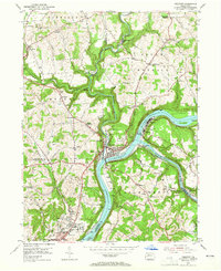
1953 Map of Freeport
USGS Topo · Published 1965About this map
The confluence of the Allegheny River and Kiskiminetas River anchors this mid-century survey of the industrial and residential corridors of western Pennsylvania. Freeport occupies the critical junction where the rivers meet, flanked by railroad infrastructure such as Kiskiminetas Junction and the complex of tracks serving Butler Junction. The landscape transitions from the riverfront industries and Brick Kilns to the growing residential areas of Natrona Heights and Birdville in the south, reflecting the post-war expansion of these Allegheny Valley communities.
Find a feature on this map
74 named features on this map. Tap any name to fly to it.
Don’t see what you’re looking for? This feature index may not catch every label — zoom into the map to look around manually.
Map Details
Editions of this 1953 Freeport Map
4 editions found
Other maps of this area

1900 · Kittanning
USGS Topo · 1:62,500

1902 · Kittanning
USGS Topo · 1:62,500

1907 · Freeport
USGS Topo · 1:62,500

1908 · New Kensington
USGS Topo · 1:62,500

1909 · Freeport
USGS Topo · 1:62,500

1909 · Butler
USGS Topo · 1:62,500

1910 · New Kensington
USGS Topo · 1:62,500

1911 · Butler
USGS Topo · 1:62,500

1953 · Pittsburgh
USGS Topo · 1:250,000

1953 · New Kensington East
USGS Topo · 1:24,000
Featured Places
- Harrison Township, PA
- Freeport, PA
- Buffalo Township, PA
- Winfield Township, PA
- South Buffalo Township, PA