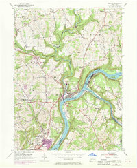
1953 Map of Freeport
USGS Topo · Published 1970About this map
The confluence of the Allegheny River and Kiskiminetas River serves as the industrial and logistical heart of this 1953 landscape. The river banks are lined with rail infrastructure, including the Penn Central and Pittsburgh and Shawmut lines, which supported the movement of goods from nearby operations like the Strip Mine north of Silverville. To the south, the expansion of Natrona Heights and Birdville reflects the mid-century growth of residential communities alongside established industrial centers. Genealogists will find significant detail in the numerous burial grounds and religious sites scattered across the township lines, including Mount Airy Cemetery, Brookland Cem, and St Marys Cem. The presence of the Transylvania Bible School and several local schools like Sloan Sch and Bagdad Sch further illustrates the social fabric of these riverfront and upland settlements.
Find a feature on this map
68 named features on this map. Tap any name to fly to it.
Don’t see what you’re looking for? This feature index may not catch every label — zoom into the map to look around manually.
Map Details
Editions of this 1953 Freeport Map
4 editions found
Other maps of this area

1900 · Kittanning
USGS Topo · 1:62,500

1902 · Kittanning
USGS Topo · 1:62,500

1907 · Freeport
USGS Topo · 1:62,500

1908 · New Kensington
USGS Topo · 1:62,500

1909 · Freeport
USGS Topo · 1:62,500

1909 · Butler
USGS Topo · 1:62,500

1910 · New Kensington
USGS Topo · 1:62,500

1911 · Butler
USGS Topo · 1:62,500

1953 · Pittsburgh
USGS Topo · 1:250,000

1953 · New Kensington East
USGS Topo · 1:24,000
Featured Places
- Harrison Township, PA
- Freeport, PA
- Buffalo Township, PA
- Winfield Township, PA
- South Buffalo Township, PA