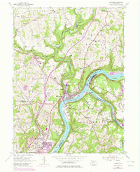
1953 Map of Freeport
USGS Topo · Published 1979About this map
The confluence of the Allegheny River and Kiskiminetas River anchors this industrial landscape, where steep river bluffs meet a complex network of rail and water transport. Freeport sits as the primary hub, surrounded by smaller settlements like Laneville and Butler Junction. The river banks are marked by heavy industry and infrastructure, including a Mine and Pumping Sta near Schenley, and the critical rail nexus at Kiskiminetas Junction.
Find a feature on this map
67 named features on this map. Tap any name to fly to it.
Don’t see what you’re looking for? This feature index may not catch every label — zoom into the map to look around manually.
Map Details
Editions of this 1953 Freeport Map
4 editions found
Other maps of this area

1900 · Kittanning
USGS Topo · 1:62,500

1902 · Kittanning
USGS Topo · 1:62,500

1907 · Freeport
USGS Topo · 1:62,500

1908 · New Kensington
USGS Topo · 1:62,500

1909 · Freeport
USGS Topo · 1:62,500

1909 · Butler
USGS Topo · 1:62,500

1910 · New Kensington
USGS Topo · 1:62,500

1911 · Butler
USGS Topo · 1:62,500

1953 · Pittsburgh
USGS Topo · 1:250,000

1953 · New Kensington East
USGS Topo · 1:24,000
Featured Places
- Harrison Township, PA
- Freeport, PA
- Buffalo Township, PA
- Winfield Township, PA
- South Buffalo Township, PA