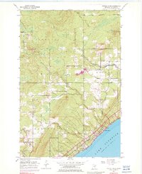
1953 Map of French River
USGS Topo · Published 1982About this map
The rugged shoreline of Lake Superior meets a network of vital waterways in this mid-century look at the North Shore. The Duluth Missabe and Iron Range railroad hugs the coast, serving as a corridor for industrial transport through Clifton and across the French River. Inland, the map reveals the scattered rural development of Normanna and Lakewood, where local civic life centered around landmarks like the Normanna Cem and the Town Hall.
Find a feature on this map
26 named features on this map. Tap any name to fly to it.
Don’t see what you’re looking for? This feature index may not catch every label — zoom into the map to look around manually.
Map Details
Editions of this 1953 French River Map
4 editions found
Other maps of this area

1895 · Duluth
USGS Topo · 1:62,500

1953 · Lakewood
USGS Topo · 1:24,000

1953 · French River
USGS Topo · 1:24,000

1953 · Arnold
USGS Topo · 1:24,000

1953 · Duluth
USGS Topo · 1:24,000

1953 · Knife River
USGS Topo · 1:24,000

1953 · Duluth
USGS Topo · 1:62,500

1953 · Ashland
USGS Topo · 1:250,000

1953 · Duluth
USGS Topo · 1:250,000

1954 · Barrs Lake
USGS Topo · 1:24,000