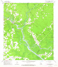
1963 Map of French Settlement
USGS Topo · Published 1964About this map
The Amite River carves a winding path through this low-lying landscape along the border of Livingston and Ascension Parishes. In the early 1960s, the region was defined by a complex network of bayous and cypress-choked wetlands like St Amant Swamp. Small riverside communities such as Port Vincent and French Settlement served as local anchors, their development closely tied to the water. The map documents significant local landmarks including Lady of the Lake Ch and Our Lady Chapel, alongside small family burial grounds like Watson Cem and Feider Cem.
Find a feature on this map
55 named features on this map. Tap any name to fly to it.
Don’t see what you’re looking for? This feature index may not catch every label — zoom into the map to look around manually.
Map Details
Editions of this 1963 French Settlement Map
3 editions found
Other maps of this area

1892 · Mount Airy
USGS Topo · 1:62,500

1892 · Donaldsonville
USGS Topo · 1:62,500

1934 · Denham Springs
USGS Topo · 1:62,500

1934 · Springfield
USGS Topo · 1:62,500

1935 · Gonzales
USGS Topo · 1:31,680

1939 · Springfield
USGS Topo · 1:62,500

1939 · Denham Springs
USGS Topo · 1:62,500

1939 · Donaldsonville
USGS Topo · 1:62,500

1946 · Petite Amite River
USGS Topo · 1:31,680

1947 · Sorrento
USGS Topo · 1:31,680