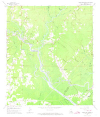
1963 Map of French Settlement
USGS Topo · Published 1973About this map
The Amite River meanders through this 1963 survey of the borderlands between Livingston and Ascension Parishes. The landscape is dominated by the complex hydrology of the St Amant Swamp, where numerous bayous like Cocodrie Bayou and Poley Bayou drain into larger basins such as Lake Villars and Lake Martin. Settlement patterns follow the high ground and riverbanks, most notably at the namesake French Settlement and the river port of Port Vincent. The map provides significant genealogical value, documenting numerous remote house sites and local landmarks of faith including Lady of the Lake Ch, Faithful Ch, and Our Lady Chapel. To the south, the Amite River Diversion Canal represents a significant man-made alteration to the natural drainage of the swamp, cutting through the area near Laurel Ridge and Seles Point.
Find a feature on this map
54 named features on this map. Tap any name to fly to it.
Don’t see what you’re looking for? This feature index may not catch every label — zoom into the map to look around manually.
Map Details
Editions of this 1963 French Settlement Map
3 editions found
Other maps of this area

1892 · Mount Airy
USGS Topo · 1:62,500

1892 · Donaldsonville
USGS Topo · 1:62,500

1934 · Denham Springs
USGS Topo · 1:62,500

1934 · Springfield
USGS Topo · 1:62,500

1935 · Gonzales
USGS Topo · 1:31,680

1939 · Springfield
USGS Topo · 1:62,500

1939 · Denham Springs
USGS Topo · 1:62,500

1939 · Donaldsonville
USGS Topo · 1:62,500

1946 · Petite Amite River
USGS Topo · 1:31,680

1947 · Sorrento
USGS Topo · 1:31,680