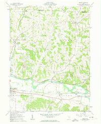
1961 Map of Fresno
USGS Topo · Published 1963About this map
The Tuscarawas River carves a broad valley through the center of this landscape, anchoring a corridor of industrial and agricultural activity. The lowlands, known as The Plains, are marked by the presence of the Pennsylvania railroad and the community of West Lafayette. To the north, the terrain becomes more dissected, with steep ridges like Hothem Ridge and Chestnut Ridge separating small valleys such as Progressive Valley.
Find a feature on this map
57 named features on this map. Tap any name to fly to it.
Don’t see what you’re looking for? This feature index may not catch every label — zoom into the map to look around manually.
Map Details
Editions of this 1961 Fresno Map
4 editions found
Other maps of this area

1908 · Conesville
USGS Topo · 1:62,500

1909 · Cambridge
USGS Topo · 1:62,500

1910 · Conesville
USGS Topo · 1:62,500

1911 · Newcomerstown
USGS Topo · 1:62,500

1912 · Cambridge
USGS Topo · 1:62,500

1913 · Newcomerstown
USGS Topo · 1:62,500

1913 · Coshocton
USGS Topo · 1:62,500

1915 · Coshocton
USGS Topo · 1:62,500

1943 · Coshocton
USGS Topo · 1:62,500

1943 · Newcomerstown
USGS Topo · 1:62,500