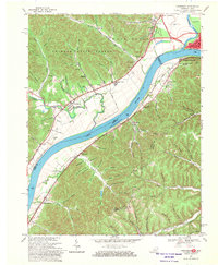
1968 Map of Friendship
USGS Topo · Published 1970About this map
The Ohio River carves a deep valley between the Kentucky and Ohio borders, serving as the central artery for the region's transport and industry in the late 1960s. On the northern bank, the Shawnee State Forest dominates the terrain with a dense network of hollows like Walker Hollow and Bradford Hollow, while the urban reach of Portsmouth and West Portsmouth anchors the eastern edge near the confluence with the Scioto River. Across the water in Kentucky, the Chesapeake and Ohio railroad tracks hug the shoreline, connecting riverside hamlets like Firebrick and South Portsmouth.
Find a feature on this map
101 named features on this map. Tap any name to fly to it.
Don’t see what you’re looking for? This feature index may not catch every label — zoom into the map to look around manually.
Map Details
Editions of this 1968 Friendship Map
3 editions found
Other maps of this area

1911 · Sciotoville
USGS Topo · 1:62,500

1913 · Sciotoville
USGS Topo · 1:62,500

1915 · Garrison
USGS Topo · 1:62,500

1915 · Otway
USGS Topo · 1:62,500

1917 · Otway
USGS Topo · 1:62,500

1918 · Garrison
USGS Topo · 1:62,500

1926 · Greenup
USGS Topo · 1:48,000

1930 · Greenup
USGS Topo · 1:62,500

1949 · Pond Run
USGS Topo · 1:24,000

1949 · Garrison
USGS Topo · 1:24,000