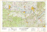
1956 Map of Gadsden
USGS Topo · Published 1978About this map
The Tennessee River corridor defines this mid-century portrait of North Alabama, showing the massive impoundments of Wheeler Lake, Wilson Lake, and Guntersville Lake at their height. The map documents the industrial and military expansion of the era, notably the sprawling Redstone Arsenal near Huntsville and the established manufacturing centers at Decatur and Gadsden. Significant transportation infrastructure is recorded, including the historic Natchez Trace Parkway and the complex rail network of the Southern Railway, Louisville & Nashville RR, and Illinois Central RR.
Find a feature on this map
63 named features on this map. Tap any name to fly to it.
Don’t see what you’re looking for? This feature index may not catch every label — zoom into the map to look around manually.
Map Details
Editions of this 1956 Gadsden Map
3 editions found

Other maps of this area

1885 · Gadsden
USGS Topo · 1:125,000

1886 · Stevenson
USGS Topo · 1:125,000

1888 · Cullman
USGS Topo · 1:125,000

1888 · Gadsden
USGS Topo · 1:125,000

1888 · Scottsboro
USGS Topo · 1:125,000

1888 · Huntsville
USGS Topo · 1:125,000

1889 · Springville
USGS Topo · 1:125,000

1889 · Birmingham
USGS Topo · 1:125,000

1892 · Cullman
USGS Topo · 1:125,000

1892 · Birmingham
USGS Topo · 1:125,000