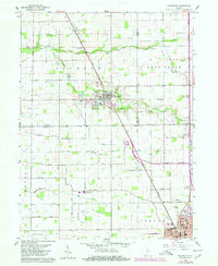
1959 Map of Galveston
USGS Topo · Published 1980About this map
Galveston is the primary hub of this North Central Indiana survey, situated at the intersection of the Conrail line and the historic Dixie Highway. The landscape is defined by an extensive network of drainage infrastructure, such as the Charles Templeton Ditch and Sarah Hollipeter Ditch, which support the region's agricultural productivity. To the north, the winding course of Deer Creek and its South Fork provide the primary natural relief in an otherwise strictly gridded territory.
Find a feature on this map
55 named features on this map. Tap any name to fly to it.
Don’t see what you’re looking for? This feature index may not catch every label — zoom into the map to look around manually.
Map Details
Editions of this 1959 Galveston Map
3 editions found
Other maps of this area

1951 · Onward
USGS Topo · 1:24,000

1951 · Bunker Hill
USGS Topo · 1:24,000

1953 · Danville
USGS Topo · 1:250,000

1955 · Danville
USGS Topo · 1:250,000

1955 · Anoka
USGS Topo · 1:24,000

1956 · Danville
USGS Topo · 1:250,000

1959 · Galveston
USGS Topo · 1:24,000

1959 · Miami
USGS Topo · 1:24,000

1959 · Young America
USGS Topo · 1:24,000

1960 · Kokomo West
USGS Topo · 1:24,000