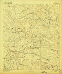
1894 Map of Gatesville
USGS Topo · Published 1920About this map
Gatesville serves as the focal point of this late 19th-century survey, situated at a major crossing of the Leon River. The landscape is defined by a dense network of gaps and peaks, where early Texas settlements like Fort Gates and Straws Mill follow the river's winding path. This reconnaissance survey, conducted by H.S. Wallace in 1886, illustrates a transition from livestock ranching to a rail-based economy. The St. Louis Arkansas and Texas Railroad links Leon Junction to the county seat, while the Gulf Colorado and Santa Fe Railroad cuts through the southern reaches, connecting Coperas Cove, Killeen, and Nolanville. Local geography is marked by numerous family-named landmarks and strategic passes, including Pidcock Ranch on Beehouse Creek and the prominent Sugar Loaf Mountain.
Find a feature on this map
89 named features on this map. Tap any name to fly to it.
Don’t see what you’re looking for? This feature index may not catch every label — zoom into the map to look around manually.
Map Details
Editions of this 1894 Gatesville Map
4 editions found

Other maps of this area

1885 · Taylor
USGS Topo · 1:125,000

1887 · Taylor
USGS Topo · 1:125,000

1887 · Lampasas
USGS Topo · 1:125,000

1887 · Burnet
USGS Topo · 1:125,000

1888 · Hamilton
USGS Topo · 1:125,000

1888 · Meridian
USGS Topo · 1:125,000

1892 · Temple
USGS Topo · 1:125,000

1892 · Waco
USGS Topo · 1:125,000

1893 · Georgetown
USGS Topo · 1:125,000

1893 · Burnet
USGS Topo · 1:125,000