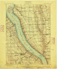
1902 Map of Genoa
USGS Topo · Published 1909About this map
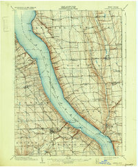
Cayuga Lake dominates the center of this 1902 survey, serving as a primary transportation corridor with a marked Steamboat Route and various Ferry crossings connecting the eastern and western shores. The landscape reflects a turn-of-the-century agricultural and educational hub, anchored by Wells College in the northwest. Industrial and transit connectivity is evident through the Lehigh Valley Railroad, which operates both an Ithaca Branch and an Auburn Branch to move goods and passengers through the Finger Lakes region. Small hamlets like King Ferry, Poplar Ridge, and Genoa dot the uplands above the deep ravines of Salmon Creek. The map also captures the dramatic topography of Taughannic Falls near the southern edge, highlighting the area's natural landmarks before the era of modern highway development.
Find a feature on this map
65 named features on this map. Tap any name to fly to it.
Don’t see what you’re looking for? This feature index may not catch every label — zoom into the map to look around manually.
Map Details
Editions of this 1902 Genoa Map
8 editions found

Other maps of this area

1893 · Ithaca
USGS Topo · 1:62,500

1895 · Ithaca
USGS Topo · 1:62,500

1898 · Moravia
USGS Topo · 1:62,500

1898 · Watkins Glen
USGS Topo · 1:62,500

1899 · Auburn
USGS Topo · 1:62,500

1899 · Skaneateles
USGS Topo · 1:62,500

1900 · Dryden
USGS Topo · 1:62,500

1901 · Watkins
USGS Topo · 1:62,500

1902 · Skaneateles
USGS Topo · 1:62,500

1902 · Geneva
USGS Topo · 1:62,500