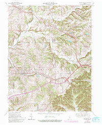
1966 Map of Georgetown
USGS Topo · Published 1993About this map
Greenville and Galena anchor the northern reaches of this Floyd County landscape, where the terrain transitions into a series of prominent ridges and knobs. The topography is defined by the steep rises of Tunnel Hill and Pear Ridge, with the Southern railroad line navigating the difficult grade through the center of the quadrangle. Local landmarks such as the Mt St Francis Seminary and the Galena Sch & Ch reflect the established rural community centers of the mid-20th century.
Find a feature on this map
41 named features on this map. Tap any name to fly to it.
Don’t see what you’re looking for? This feature index may not catch every label — zoom into the map to look around manually.
Map Details
Editions of this 1966 Georgetown Map
4 editions found
Other maps of this area

1909 · Kosmosdale
USGS Topo · 1:48,000

1912 · Kosmosdale
USGS Topo · 1:62,500

1931 · Corydon
USGS Topo · 1:62,500

1938 · Speed
USGS Topo · 1:24,000

1939 · New Albany
USGS Topo · 1:24,000

1939 · Georgetown
USGS Topo · 1:24,000

1941 · Borden
USGS Topo · 1:24,000

1946 · New Albany
USGS Topo · 1:24,000

1947 · Speed
USGS Topo · 1:24,000

1947 · Georgetown
USGS Topo · 1:24,000