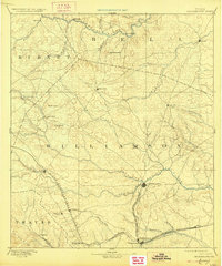
1893 Map of Georgetown
USGS Topo · Published 1927About this map
The confluence of the North Fork San Gabriel River and South Fork San Gabriel River anchors the central landscape of this 1885 survey of Williamson and surrounding counties. This era of Texas history is defined by the rapid expansion of rail lines through the Blackland Prairie and Hill Country transition, notably the International and Great Northern Railroad passing through Georgetown and the Austin and Northwestern Railroad connecting Liberty Hill and Leander. The map captures a moment when both Old Round Rock and the newer Round Rock rail settlement existed simultaneously.
Find a feature on this map
47 named features on this map. Tap any name to fly to it.
Don’t see what you’re looking for? This feature index may not catch every label — zoom into the map to look around manually.
Map Details
Editions of this 1893 Georgetown Map
5 editions found
Other maps of this area

1885 · Taylor
USGS Topo · 1:125,000

1885 · Bastrop
USGS Topo · 1:125,000

1887 · Taylor
USGS Topo · 1:125,000

1887 · Lampasas
USGS Topo · 1:125,000

1887 · Blanco
USGS Topo · 1:125,000

1887 · Burnet
USGS Topo · 1:125,000

1892 · Temple
USGS Topo · 1:125,000

1893 · Georgetown
USGS Topo · 1:125,000

1893 · Burnet
USGS Topo · 1:125,000

1893 · Bastrop
USGS Topo · 1:125,000