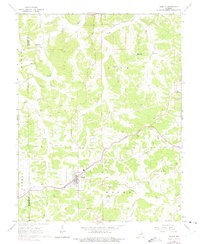
1966 Map of Gerald
USGS Topo · Published 1975About this map
The town of Gerald anchors this mid-century topographic portrait of eastern Missouri, serving as a key waypoint along the Chicago Rock Island and Pacific railroad. The landscape is defined by the winding paths of Boeuf Creek and its many tributaries, including Barren Fork Boeuf Creek and Pin Oak Creek, which carve through the townships of Lyon, Canaan, and Boone. Small rural communities like Beemont and Port Hudson dot the outskirts, connected by a network of unimproved roads and field lines.
Find a feature on this map
32 named features on this map. Tap any name to fly to it.
Don’t see what you’re looking for? This feature index may not catch every label — zoom into the map to look around manually.
Map Details
Editions of this 1966 Gerald Map
3 editions found
Other maps of this area

1890 · Hermann
USGS Topo · 1:125,000

1903 · Sullivan
USGS Topo · 1:125,000

1935 · Gerald
USGS Topo · 1:48,000

1936 · Hermann
USGS Topo · 1:48,000

1941 · Gerald
USGS Topo · 1:62,500

1942 · Hermann
USGS Topo · 1:62,500

1944 · Gerald
USGS Topo · 1:62,500

1945 · Hermann
USGS Topo · 1:62,500

1946 · Union
USGS Topo · 1:62,500

1948 · Union
USGS Topo · 1:62,500