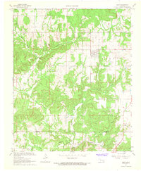
1967 Map of Gerty
USGS Topo · Published 1968About this map
Gerty serves as the primary settlement in this part of Hughes County, situated just north of the border with Coal County. The landscape is defined by an intricate network of waterways, most notably the winding course of Muddy Boggy Creek and the drainage systems of Sandy Creek and Salt Creek. The presence of the Ne Citra Oil and Gas Field indicates the region's industrial ties to petroleum extraction, which sits in contrast to the rural character suggested by several gravel pits and scattered country landmarks. Genealogists and local historians can find specific points of interest such as the Gerty Cem and the Panther Creek Cem, alongside religious centers like Salt Creek Ch. The map's detail extends to various smaller tributaries including Little Sandy Creek and Beaver Creek, illustrating the complex hydrology of the Oklahoma interior during the late 1960s.
Find a feature on this map
19 named features on this map. Tap any name to fly to it.
Don’t see what you’re looking for? This feature index may not catch every label — zoom into the map to look around manually.
Map Details
Editions of this 1967 Gerty Map
3 editions found
Other maps of this area

1896 · Coalgate
USGS Topo · 1:125,000

1899 · Coalgate
USGS Topo · 1:125,000

1900 · Coalgate
USGS Topo · 1:125,000

1957 · Tupelo NE
USGS Topo · 1:24,000

1957 · Ardmore
USGS Topo · 1:250,000

1958 · Lula
USGS Topo · 1:24,000

1958 · Steedman
USGS Topo · 1:24,000

1963 · Ardmore
USGS Topo · 1:250,000

1967 · Calvin East
USGS Topo · 1:24,000
1967 · Non
USGS Topo · 1:24,000