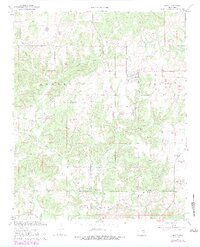
1967 Map of Gerty
USGS Topo · Published 1979About this map
The town of Gerty serves as the focal point of this landscape in southern Oklahoma, surrounded by a complex network of rural cemeteries and drainage systems. This 1967 survey captures the area as the NE Citra Oil and Gas Field shaped local land use, interspersed with active Gravel Pits and traditional homestead patterns. The geography is defined by its watercourses, notably Big Sandy Creek and Little Sandy Creek in the north, and the southern flow of Muddy Boggy Creek. Small community hubs are evidenced by the presence of Salt Creek Ch and the Panther Creek Cem, which, along with the Gerty Cem, provide essential data points for family historians. The map also delineates the boundary between Hughes Co and Coal Co, showing the intersection of civic administration and the natural terrain.
Find a feature on this map
17 named features on this map. Tap any name to fly to it.
Don’t see what you’re looking for? This feature index may not catch every label — zoom into the map to look around manually.
Map Details
Editions of this 1967 Gerty Map
3 editions found
Other maps of this area

1896 · Coalgate
USGS Topo · 1:125,000

1899 · Coalgate
USGS Topo · 1:125,000

1900 · Coalgate
USGS Topo · 1:125,000

1957 · Tupelo NE
USGS Topo · 1:24,000

1957 · Ardmore
USGS Topo · 1:250,000

1958 · Lula
USGS Topo · 1:24,000

1958 · Steedman
USGS Topo · 1:24,000

1963 · Ardmore
USGS Topo · 1:250,000

1967 · Calvin East
USGS Topo · 1:24,000
1967 · Non
USGS Topo · 1:24,000