
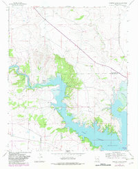
1966 Map of Gibbons Ranch
USGS Topo · Published 1968About this map
The Alamogordo Reservoir dominates the landscape of this 1966 survey, filling the basin where the Pecos River and Alamogordo Creek converge. This era shows the controlled inundation areas along the shoreline, reflecting the water management infrastructure critical to this arid New Mexico region. Cultural landmarks are scattered throughout the surrounding rangeland, including the eponymous Gibbons Ranch and the small settlement at Los Ojitos. Evidence of earlier habitation appears as several marked ruins to the north and west of the reservoir, while the drainage of Arroyo Potrillo carves through the eastern terrain. Springs located near the reservoir's northern finger suggest the vital natural water sources that preceded the dam's construction. This map provides a clear view of the transition between the natural river valley and the artificial lake that reshaped the Guadalupe and De Baca county line.
Find a feature on this map
10 named features on this map. Tap any name to fly to it.
Don’t see what you’re looking for? This feature index may not catch every label — zoom into the map to look around manually.
Map Details
Editions of this 1966 Gibbons Ranch Map
2 editions found
Other maps of this area

1954 · Fort Sumner
USGS Topo · 1:250,000

1958 · Fort Sumner
USGS Topo · 1:250,000

1963 · Puerto De Luna
USGS Topo · 1:24,000

1964 · Canada Colorado
USGS Topo · 1:24,000

1964 · Fallon Ranch
USGS Topo · 1:24,000

1965 · Windmill Draw
USGS Topo · 1:24,000

1966 · Ojo Negro Creek
USGS Topo · 1:24,000

1966 · Alamogordo Dam
USGS Topo · 1:24,000

1966 · Cooper Ranch
USGS Topo · 1:24,000

1966 · Colorado Canyon
USGS Topo · 1:24,000