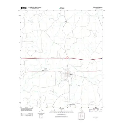
2012 Map of Gibsland
USGS Topo · Published 2012About this map
Gibsland serves as the central hub of this northern Louisiana landscape, where the local street grid intersects with a network of rural roads and parish routes. To the south, the historic community of Mount Lebanon stands near the headwaters of Frazier Cr, while the settlements of Taylor and Phillips lie to the west along the rail corridor. The map reveals a heavily dendritic drainage pattern characterized by numerous named branches and creeks, such as Black Lake Cr and Leatherman Cr, which snake through the varied terrain. Genealogists will find several family-named landmarks and burial sites, including Caldwell Cem in the north and Whitley Cem near the central drainage basins. This 2012 survey illustrates a region where timberlands and small agricultural plots are divided by long-established thoroughfares like Old Arcadia Rd and Iron Bridge Rd.
Find a feature on this map
84 named features on this map. Tap any name to fly to it.
Don’t see what you’re looking for? This feature index may not catch every label — zoom into the map to look around manually.
Map Details
Editions of this 2012 Gibsland Map
This is the sole edition of this map. No revisions or reprints were ever made.
Other maps of this area

1947 · Bienville
USGS Topo · 1:62,500

1948 · Jamestown
USGS Topo · 1:62,500

1949 · Jamestown
USGS Topo · 1:62,500

1949 · Bienville
USGS Topo · 1:62,500

1949 · Gibsland
USGS Topo · 1:62,500

1950 · Gibsland
USGS Topo · 1:62,500

1950 · Arcadia
USGS Topo · 1:62,500

1951 · Arcadia
USGS Topo · 1:62,500

1955 · Shreveport
USGS Topo · 1:250,000

1956 · Shreveport
USGS Topo · 1:250,000