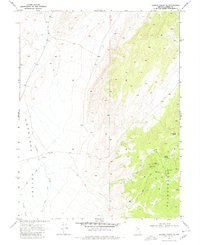
1969 Map of Gilbert Creek SE
USGS Topo · Published 1980About this map
The high-desert terrain of Ravenswood and the broad expanses of Antelope Valley define this late-1960s survey of Lander County. This arid landscape is punctuated by vital water sources such as Caton Spring, Rocky Gap Spring, and the ephemeral Gilbert Creek. The presence of the Red Bird Mine, along with individual mining features like the Queen Shaft and Pine Shaft, highlights the region's legacy of subsurface exploration and mineral extraction. A network of Jeep Trails provides the primary means of navigation through the varying elevations, connecting remote points like the 5401 Well with the surrounding mountain ranges. This map captures a specific moment in the mid-century Great Basin, where the sparse placement of wells and mine shafts tells the story of a working landscape defined by its limited water and potential for ore.
Find a feature on this map
12 named features on this map. Tap any name to fly to it.
Don’t see what you’re looking for? This feature index may not catch every label — zoom into the map to look around manually.
Map Details
Editions of this 1969 Gilbert Creek SE Map
2 editions found
Other maps of this area

1955 · Millett
USGS Topo · 1:250,000

1959 · Millett
USGS Topo · 1:250,000

1969 · Manhattan Mtn
USGS Topo · 1:24,000

1969 · Gilbert Creek SE
USGS Topo · 1:24,000
1969 · Manhattan Mtn NW
USGS Topo · 1:24,000

1969 · Gilbert Creek SW
USGS Topo · 1:24,000
1969 · Gilbert Creek NW
USGS Topo · 1:24,000
1969 · Gilbert Creek NE
USGS Topo · 1:24,000

1969 · Vigus Butte NW
USGS Topo · 1:24,000

1969 · Mount Airy NW
USGS Topo · 1:24,000