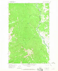
1958 Map of Glenn Creek
USGS Topo · Published 1968About this map
The Lewis and Clark National Forest and the Sun River Game Preserve define this landscape, where the North Fork Sun River carves a deep valley between high peaks. This 1958 field survey shows a wilderness area shaped by administrative boundaries, notably where the Teton and Lewis and Clark County line follows the river's path. Human presence is concentrated at the Cabin Creek Guard Station, a key outpost for mountain management near the convergence of the Cabin Creek and the main river. The map details a complex network of pack trails that provided the primary means of travel through this remote interior, connecting landmarks like Sulphur Creek Lick and Two Shacks Flat. Higher elevations are marked by prominent summits such as Sheep Mtn and Slategoat Mtn, overseeing the drainage of Glenn Creek and Moose Creek.
Find a feature on this map
25 named features on this map. Tap any name to fly to it.
Don’t see what you’re looking for? This feature index may not catch every label — zoom into the map to look around manually.
Map Details
Editions of this 1958 Glenn Creek Map
4 editions found
Other maps of this area

1903 · Saypo
USGS Topo · 1:125,000

1936 · Silvertip
USGS Topo · 1:96,000

1942 · Silvertip
USGS Topo · 1:125,000

1955 · Choteau
USGS Topo · 1:250,000

1957 · Choteau
USGS Topo · 1:250,000

1958 · Choteau
USGS Topo · 1:250,000

1958 · Our Lake
USGS Topo · 1:24,000

1958 · Glenn Creek
USGS Topo · 1:24,000

1958 · Pretty Prairie
USGS Topo · 1:24,000

1958 · Gates Park
USGS Topo · 1:24,000