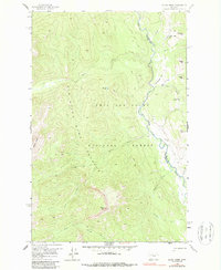
1958 Map of Glenn Creek
USGS Topo · Published 1987About this map
The Sun River Game Preserve Bdy defines the western half of this landscape, where the confluence of the North Fork Sun River and South Fork Sun River shapes the local drainage. Established within the Lewis and Clark National Forest, the area is characterized by high-elevation landforms including White Ridge and Sheep Mtn. A network of designated pack trails serves as the primary means of navigation through the steep terrain, connecting points of interest like Hazard Lake and the Cabin Creek Guard Station.
Find a feature on this map
25 named features on this map. Tap any name to fly to it.
Don’t see what you’re looking for? This feature index may not catch every label — zoom into the map to look around manually.
Map Details
Editions of this 1958 Glenn Creek Map
4 editions found
Other maps of this area

1903 · Saypo
USGS Topo · 1:125,000

1936 · Silvertip
USGS Topo · 1:96,000

1942 · Silvertip
USGS Topo · 1:125,000

1955 · Choteau
USGS Topo · 1:250,000

1957 · Choteau
USGS Topo · 1:250,000

1958 · Choteau
USGS Topo · 1:250,000

1958 · Our Lake
USGS Topo · 1:24,000

1958 · Glenn Creek
USGS Topo · 1:24,000

1958 · Pretty Prairie
USGS Topo · 1:24,000

1958 · Gates Park
USGS Topo · 1:24,000