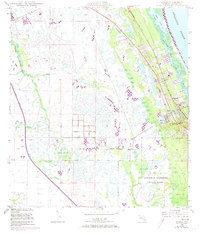
1948 Map of Gomez
USGS Topo · Published 1973About this map
Jupiter Island and the adjacent mainland represent the coastal character of Martin County during a period of significant post-war infrastructure development. The Intracoastal Waterway separates the island from the mainland, where the established communities of Gomez and Hobe Sound sit along the Florida East Coast rail line. This 1948 survey, updated with 1967 aerial revisions, shows the transition from the marshy interior of Jonathan Dickinson State Park to the developing residential patterns in Banner Lake and Olympia.
Find a feature on this map
20 named features on this map. Tap any name to fly to it.
Don’t see what you’re looking for? This feature index may not catch every label — zoom into the map to look around manually.
Map Details
Editions of this 1948 Gomez Map
5 editions found
Other maps of this area

1948 · Palm City
USGS Topo · 1:24,000

1948 · Rood
USGS Topo · 1:24,000

1948 · St. Lucie Inlet
USGS Topo · 1:24,000

1948 · Gomez
USGS Topo · 1:24,000

1948 · Hobe Sound
USGS Topo · 1:24,000

1948 · Jupiter
USGS Topo · 1:24,000

1949 · Rood
USGS Topo · 1:24,000

1949 · Gomez
USGS Topo · 1:24,000

1949 · Hobe Sound
USGS Topo · 1:24,000

1950 · St. Lucie Inlet
USGS Topo · 1:24,000