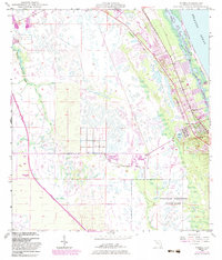
1948 Map of Gomez
USGS Topo · Published 1983About this map
The Florida East Coast railway corridor serves as the primary axis for development in Martin County, anchoring the settlements of Gomez and Hobe Sound. This 1948 survey, updated with 1980s data, illustrates the coastal evolution of the Treasure Coast, where the Intracoastal Waterway carves through Peck Lake and the Hobe Sound lagoon. Large tracts of land are dedicated to conservation, notably the Jonathan Dickinson State Park to the south and the Hobe Sound National Wildlife Refuge on Jupiter Island.
Find a feature on this map
21 named features on this map. Tap any name to fly to it.
Don’t see what you’re looking for? This feature index may not catch every label — zoom into the map to look around manually.
Map Details
Editions of this 1948 Gomez Map
5 editions found
Other maps of this area

1948 · Palm City
USGS Topo · 1:24,000

1948 · Rood
USGS Topo · 1:24,000

1948 · St. Lucie Inlet
USGS Topo · 1:24,000

1948 · Gomez
USGS Topo · 1:24,000

1948 · Hobe Sound
USGS Topo · 1:24,000

1948 · Jupiter
USGS Topo · 1:24,000

1949 · Rood
USGS Topo · 1:24,000

1949 · Gomez
USGS Topo · 1:24,000

1949 · Hobe Sound
USGS Topo · 1:24,000

1950 · St. Lucie Inlet
USGS Topo · 1:24,000