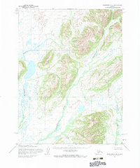
1954 Map of Goodnews A-3
USGS Topo · Published 1983About this map
Negukthlik River and the Ungalikthluk River dominate this Southwestern Alaska landscape, weaving through a complex network of glacial valleys and upland ridges. The drainage patterns revealed here reflect a wilderness largely untouched by permanent settlements or industrial infrastructure during the mid-1950s. The Kulukak River defines the eastern portion of the quadrangle, carving through high-relief terrain that transitions into broad, marshy lowlands filled with unnamed lakes and ponds. This Army Map Service survey, later edited by the U.S. Geological Survey, emphasizes the natural topography and waterway systems in an era when no roads or trails were recorded in the area, highlighting the importance of river systems for inland navigation and geographic orientation.
Find a feature on this map
3 named features on this map. Tap any name to fly to it.
Don’t see what you’re looking for? This feature index may not catch every label — zoom into the map to look around manually.
Map Details
Editions of this 1954 Goodnews A-3 Map
2 editions found

Other maps of this area

1945 · Nushagak Bay
USGS Topo · 1:250,000

1949 · Nushagak Bay
USGS Topo · 1:250,000

1950 · Nushagak Bay D-6
USGS Topo · 1:63,360

1950 · Hagemeister Island D-1
USGS Topo · 1:63,360

1951 · Goodnews
USGS Topo · 1:250,000

1951 · Hagemeister Island
USGS Topo · 1:250,000

1951 · Nushagak Bay
USGS Topo · 1:250,000

1952 · Hagemeister Island D-1
USGS Topo · 1:63,360

1954 · Goodnews B-3
USGS Topo · 1:63,360

1954 · Goodnews A-4
USGS Topo · 1:63,360