
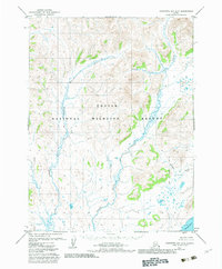
1979 Map of Goodnews Bay A-5
USGS Topo · Published 1979About this map
Togiak Bay anchors the southern edge of this Alaskan landscape, where the tides fluctuate by an average of six feet against the shoreline. This 1970s survey illustrates a region defined by its drainage systems rather than human infrastructure, as no roads or trails existed in the area at the time of publication. The Quigmy River and Matogak River wind through the terrain, joined by smaller tributaries like Sulutak Creek and the Kurtluk River. The demarcation of the Togiak Corporate Boundary in the southeast corner provides a legal footprint for the nearby community, which relies on these coastal waters and river networks. The absence of permanent structures highlights the reliance on photogrammetric methods to capture the complex, swampy lowlands and rolling elevations that characterize this portion of the Bering Sea coast.
Find a feature on this map
6 named features on this map. Tap any name to fly to it.
Don’t see what you’re looking for? This feature index may not catch every label — zoom into the map to look around manually.
Map Details
Editions of this 1979 Goodnews Bay A-5 Map
2 editions found
Other maps of this area

1947 · Hagemeister Island D-2
USGS Topo · 1:63,360

1948 · Hagemeister Island D-3
USGS Topo · 1:63,360

1951 · Goodnews
USGS Topo · 1:250,000

1951 · Hagemeister Island
USGS Topo · 1:250,000

1953 · Hagemeister Island D-2
USGS Topo · 1:63,360

1954 · Goodnews A-4
USGS Topo · 1:63,360

1954 · Goodnews A-6
USGS Topo · 1:63,360

1954 · Goodnews B-6
USGS Topo · 1:63,360

1957 · Hagemeister Island
USGS Topo · 1:250,000

1979 · Goodnews Bay B-5
USGS Topo · 1:63,360