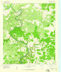
1959 Map of Gorman Falls
USGS Topo · Published 1960About this map
The Colorado River carves a dramatic, winding course through the heart of this Central Texas landscape, defining the jagged boundaries between San Saba, Lampasas, and Burnet Counties. This 1959 field-checked survey reveals a rugged ranching terrain marked by numerous springs and canyons, such as Gorman Spring and Eagle Canyon. The map details the local hydrology and topographic relief that leads to the notable Gorman Falls. Settlement is characterized by established ranching outposts including Jackson Ranch and Smith Ranch, along with recreational or seasonal sites like Lemons Springs Camp. The river itself creates distinctive landforms like McAnelly Bend and Browns Bend, while the surrounding uplands of Lemons Ridge and the Big Thicket are dissected by countless draws and hollows. Industrial activity is represented by the Southwest Ledge Quarries and various gravel pits, reflecting the area's geological utility.
Find a feature on this map
69 named features on this map. Tap any name to fly to it.
Don’t see what you’re looking for? This feature index may not catch every label — zoom into the map to look around manually.
Map Details
Editions of this 1959 Gorman Falls Map
Other maps of this area

1885 · San Saba
USGS Topo · 1:125,000

1887 · Llano
USGS Topo · 1:125,000

1887 · Lampasas
USGS Topo · 1:125,000

1887 · Burnet
USGS Topo · 1:125,000

1893 · Burnet
USGS Topo · 1:125,000

1894 · Lampasas
USGS Topo · 1:125,000

1894 · San Saba
USGS Topo · 1:125,000

1894 · Llano
USGS Topo · 1:125,000

1903 · Burnet
USGS Topo · 1:125,000

1904 · Llano
USGS Topo · 1:125,000